


 Upon reading Mark Laughlin’s recent Smile Politely article about Olympian Drive being pushed through the pastoral farmland just north of Urbana, I immediately thought of the opening scene of Douglas Adams’ The Hitchhiker’s Guide to the Galaxy. The loutish head of the Vogon Constructor Fleet addresses those about to be demolished:
“As you will no doubt be aware, the plans for development of the outlying regions of the Galaxy require the building of a hyper-spatial express route through your star system, and regrettably your planet is one of those scheduled for demolition. The process will take slightly less than two of your Earth minutes. Thank you.
“There’s no point acting all surprised about it. All the planning charts and demolition orders have been on display in your local planning department in Alpha Centauri for fifty of your Earth years, so you’ve had plenty of time to lodge any formal complaint and it’s far too late to start making a fuss about it now.
“What do you mean you’ve never been to Alpha Centauri? For heaven’s sake mankind, it’s only four light years away you know. I’m sorry, but if you can’t be bothered to take an interest in local affairs that’s your own lookout…. apathetic bloody planet, I’ve no sympathy at all.”
Champaign County Economic Development Corporation Chairman John Dimit’s comments in the article:
“[Dimit] points out that this particular extension has been in the works since the 1970’s: “It is a bit troublesome to me,” Dimit said, “that people who were well aware that the road was going to be built went ahead and purchased land up there and established businesses and are now objecting to the road. Because the road has been on the books for years. “
The people owning rural property along the Olympian right-of-way can take only cold comfort in Douglas Adams’ wicked satire.
It’s true this plan, or something similar has been on the books for a very long time. Of course, that begs the question of why a plan from the ’70s, designed for cheap fuel and urban sprawl, is still in play?
For those Smile Politely readers who don’t know, and if you’re anything like 95-plus percent of the local population, you don’t, there is a long-standing plan to build a high-speed arterial ring road around CU. Ring Road is spelled SPRAWL.
The general outline of this road has shifted over time, but this relic of the 20th century lives on like a vampire, kept alive by who knows what: Sheer inertia? Developers who see the dollar signs? Government folks who see the tax dollar signs? And planners who… who knows what planners think? I once heard one say that this plan was anti-sprawl. My thought was, “Am I missing something or are you crazy?”

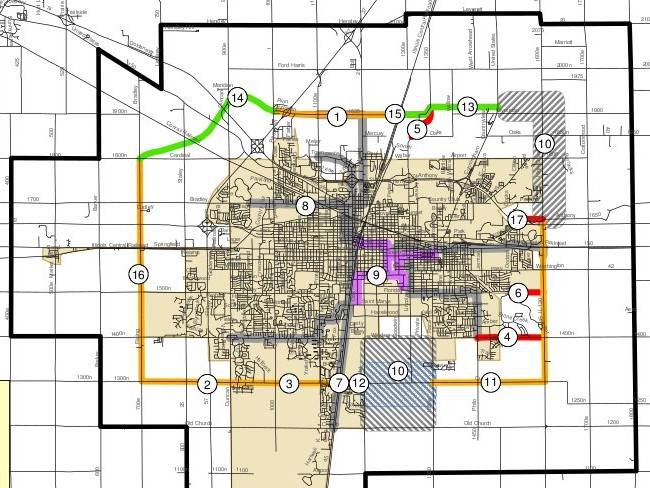
Where is this ring road you ask? Look at the map above (full image viewable as a pdf here), which is from the Champaign-Urbana Urbanized Transportation Study‘s (CUUATS) Long Range Transportation Plan (LRTP). [CUUATS is not, as the title might indicate, a study, but an entity. It’s part of the Champaign County Regional Planning Commission, also an entity, a rather large one with an astonishing number of administrative as well as planning functions.] The south leg of the Ring Road is Curtis Road. The east is Illinois 130 and High Cross Road, or perhaps also Cottonwood Road (it’s in a bit of limbo). The west also seems kind of fuzzy. It’s as far east as I-57 or as far west as Rising Road, or maybe the Piatt County line for all I know. The north is Olympian Drive, the road now at issue.
In the past few years, the proponents of The Ring Road have had a few setbacks. First, the U of I moved the South Farms to the south, where they now span Curtis Road. The College of Agriculture and Whatever Else said the idea of a four-lane expressway cutting through the middle of where herds of cattle would cross would not work out at all. Then-Urbana-Mayor Tod Satterthwaite hit the roof, saying something like, “What the Hell!? The road plan has been on the books for years!!! They should have known….. etc.” If you look on the map, you’ll see that this little section is in, shall we say, an indeterminate state.
The next setback was on the eastern leg. When Urbana was developing its comprehensive plan, adopted in 2005, the plan was drawn up to be in sync with the CUUATS LRTP. Thus it included the east link of The Ring Road, with a new interchange at High Cross Road and I-74, and then on up to Olympian Drive. Unfortunately, this is some of the more ecologically diverse and picturesque land in the county and a fair number people of live in the area. They hit the roof — and hit the public input meetings. The end result is that the east leg is no longer in the Urbana Comprehensive Plan, even though it still exists in the CUUATS plan. As the map shows, the area is under study. It’s unclear what the resolution of all this is. I suspect it’s on hold until the north leg, perhaps the most important one, is resolved.
So now there is opposition to the north leg. Apparently, the original plan was to link up the two completed sections of Olympian (which already has an Interstate interchange to I-57) along the obvious straight line. But people with houses along that line said “no way,” so the link was pushed to the north. As the Smile Politely article and comments to it note, many, if not most of the landowners in the area are adamantly opposed to this road and intend to fight it tooth and nail. On the other side, there seems to be an equal determination to push the road through. The question is why and why now?
No one on the outside seems to know. Is it simply inertia? “We’ve been planning this thing for 30-odd years and now we’re gonna build it, goddammit!” Or is it conspiratorial? “There are some big beneficiaries to this going through, but we can’t really say what they are because it would raise and galvanize opposition.” Or are there actually good reasons that haven’t been clearly articulated yet?
The quotes in the Smile Politely article point more toward the first and second. Dimit says there’s no development planned along the north leg. Urbana Public Works Director Gray says we need the leg for development. I-74 congestion is raised as a reason for it, and people go, “Wha? There’s no congestion. What kind of scam is going on here?”
Urbana is one of the strong proponents of this road. A look at the map will show you their dilemma and why they’d support this. Urbana has long had to deal with a race to the bottom with Champaign and Savoy, which usually costs it dearly, at least in the short run. Champaign’s very existence arises from the Illinois Central RR swinging to the west of Urbana. [How Savoy sprawled from a wide spot in the road is different sordid story.] I-57 did a similar thing to Urbana that the ICRR did, and it is access to this river of commerce that puts Urbana at a disadvantage. Trucking is an intensely competitive, high-volume, low-margin business. Every mile and every minute counts. Champaign has better access to the interstate system, and intends to improve it. Their plans include a new interchange for Olympian Road and I-74.
The Atkins Group Apollo Subdivision, along Olympian, but on the west side of the railroad tracks, is heavily geared toward regional warehousing and distribution. That means lots of trucks, and a desire for the most efficient highway access. Urbana wants to be connected to that. Part of the Olympian drive project is straightening out North Lincoln Avenue and connecting it to Olympian, which will benefit SuperValu’s regional grocery distribution center on North Lincoln, as well as nearby UPS and any other similar firms Urbana might attract. Urbana certainly wants these companies for their taxable value and job provision.
CU, because of its location along three (not congested) interstates, its proximity to several major markets, and its relatively low outlying land values, may be on the way to becoming a major regional distributor of food and other products, if it’s not one already. Besides SuperValu, their subsidiary W. Newell produce distribution is in a new facility in the Apollo subdivision.
The irony is that this hub of the national truck-based food distribution system is in part being challenged by local farmers trying to develop sustainable local food systems that present a much lower carbon footprint. Or it’s not ironic at all, but an opening round on what should be a long, wide and serious debate about what kind of future and economic development we want in the 21st century.
——
The LRTP is out for public comment from October 26 to Wednesday, November 25, 2009 (the day before Thanksgiving). For questions and to provide comments, contact Eric Halvorsen at 217-328-3313 or ehalvors@ccrpc.org.